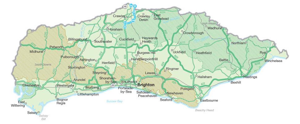
Sussex is located predominantly on the south coast of England with around 140 miles of shoreline from Camber in the east to Chichester Harbour Area of Outstanding Natural Beauty in the west.
Spanning 1,461 square miles, Sussex shares borders with Kent, Surrey and Hampshire. The South Downs National Park meets Sussex at its Hampshire border and stretches across more than half the county to Eastbourne. The Sussex county includes 1066 Country which includes the town of Battle where the famous 'Battle of Hastings in 1066' took place and from which the area now takes it name, the Wealden, which takes it name from the Old Forest that once filled much of the centre and north of the area, and Mid Sussex much of which is designated as an Area of Outstanding Natural Beauty.
The most northerly point of the county is near Gatwick Airport which is just 23 miles from the coast and the gateway to South East England by air. Sussex's geographical location with south facing slopes and a warm dry climate that makes it a prime slot for growing grapes and so the county is littered with vineyards who produce some of the best award-winning sparkling English wine in the South East. Sussex is spilt into East Sussex and West Sussex, the dividing line is not obvious when travelling through the county/counties, it is more for administrative purposes, see the map of England Sussex above which shows this beautiful county as one.
West & East Sussex both have iMaps (East Sussex iMap | West Sussex iMap) designed for all lovers of the countryside. They show all the rights of way in Sussex, as well as long distance paths, shorter walks and easy access trails. West Sussex also offers a Cycle Journey Planner, this is an ideal opportunity to see the different cycle paths within the area. Both Sussex counties have swaths of open countryside to explore which include some must see spots including Devil's Dyke and Ditchling Beacon near Brighton, Cissbury Ring near Worthing, Slindon Estate near Arundel, Cuckmere Valley near Eastbourne, Hasting Country Park, near Hastings. The Mid Sussex map, which covers around 129 square miles and is home to the High Weald National Landscape, helps you to explore the highlights of this area.
Geographically, the city of Brighton is in East Sussex and is referred to as such for postal addresses. This cosmopolitan city by the sea is the only city in East Sussex, whilst Chichester is the only city in West Sussex. In local authority terms, East and West Sussex are separately run counties and Brighton is independent of them both as a unitary authority responsible for all its local government services. Did you know that West Sussex is slightly bigger than East Sussex, 768 square miles (1991 km2) compared to 660 square miles (1792 km2).
Zoom in and out of the map using the plus and minus icons in the bottom corner while selecting the map's markers will bring up more information about one of the featured towns or villages. Alternatively, click or tap the icon at the top left corner of the map to show a full list. Some great Sussex stops include historic Arundel, artistic Brighton, traditional Littlehampton, lively Worthing, entertaining Eastbourne, noble Lewes, medieval Rye, family-friendly Bognor Regis, characterful Hastings and notable East Grinstead.
For directions, click on the icon of a red arrow in a white square that appears whenever a map marker or list item is selected.